Saturday, May 23, 2009

The Happy Ending in Anchorage

After 4,300 miles, and 15 days we finally reached the city where the RV is to be dropped off--Anchorage Alaska.

We drove to downtown Anchorage and walked along 4th avenue. Here it is today

And here is is right after the quake on March 27, 1964.


Tomorrow we will drop off the RV and heading to the airport for our flights to San Francisco.

I really liked this trip becasue I saw five new US states, and two new Canadian provinces. My favorite thing that I saw on the trip wash seeing Mount Rushmore. The hardest part of the trip was life in RV--it felt like that was my whole life.

Our Final TOTAL Route!

Friday, May 22, 2009

Denali and a Mountain Naming Controversy

We got up early and headed for the Visitors Center. There we waited for the tour bus because you can't drive in to Denali National Park. Our goal was to see all the mountains out there with no smoke like last time. We also hoped to see wildlife.

Arctic Ground Squirrel

Ptarmigan (The State Bird)
Dall SheepCaribou

Two Grizzly BearsMoose


Chris Hamilton
The mountain known to many Americans as Mount McKinley is actually known to Alaskans as Mount Denali. William Dickey wanted to rename Denali to McKinley in honor of presidential candidate William McKinley, but you have to be dead to have something named after you. So when he was assassinated in 1901 they changed the name to Mount McKinley.

Many Alaskans have been trying to change it back to its original name, Mount Denali. But a congressman from Canton Ohio (where McKinley is buried) always has pending legislation to keep the name as McKinley.

Todays Mileage -- 163 Miles (plus 104 on the bus)

Today's Route

Thursday, May 21, 2009

A Trip with MOM-- Museum, Oil, and Mountains


We did not go the the Arctic Circle today because of snow on the Dalton Highway.

So we started off the day by going to the Museum of The North at the University of Alaska, Fairbanks. It is a strikingly modern museum.

We all watched a film about the northern lights, or the aurora borealis. I learned how the the lights appear. The sun has flares that creates a solar wind of electrons. When the electrons hit an atom of oxygen or nitrogen, photons are created that glow. Fairbanks is positioned under the oval where the northern lights are.

There was also a sound room that made music from the earth's movements and the moon phases, and the northern lights. It made me feel like I was in space.

After lunch we drove north to see the Alaska Pipeline. It carries oil from the north slope to Valdez. One million barrels a day move south in it.

We then headed south to see the mountains and are going to take a tour tomorrow into Denali National Park.


Today's Mileage -- 155

Today's Route

Wednesday, May 20, 2009

Bouncing by the Border

We got up and left Burwash Landing because we a long day of driving.

Some of the roads were bouncy and were like a roller coaster. This is because of frost heaves. Under the roads are permafrost, which is permanently frozen ground. But the roads casues is to melt in the summer and refreeze in the winter. This makes the road bumpy.

We saw the highest point in Canada, Mount Logan. It is near the US border.


We stopped on the border and I had a foot in each country, the US and Canada. My Dad asked me how many times I had been to Canada and I ran between the two countries.

We are spending the night in North Pole Alaska, near Fairbanks.

Tomorrow we are not going to the Arctic Circle, but we are going to spend some time in Fairbanks and then head down to Denali.

Today's Distance -- 651 km
Today's Route

Tuesday, May 19, 2009

Dawson City CANCELLED!!

We woke up and checked road from Dawson City to Chicken--STILL CLOSED. So we decided to skip Dawson City and we headed the other way. This gave us time to stroll around Whitehorse. Whitehorse was the transportation hub of the Yukon and the capital of the territory.

We ate lunch near an old wooden bridge.

We drove Kulane Lake which is the largest lake in the Yukon Territory and saw the site where the final two sections of the Alaska Highway met.
We spent the night in beautiful Burwash Landing, home of the world's largest gold panning pan.

Today's Mileage -- 278 km
Today's Route

Monday, May 18, 2009

A quick exit from Liard, a Continental Divide lunch and into Whitehorse

After not having showers or internet for two days we wanted to get on the road quick. We had a long day of driving so we left at 7am which was early for us.

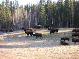
We saw about 30 wood bison(buffalo) along the road. There are only about 250 of them in British Columbia so we were excited to see such a large herd. The herd was cool because they had babies and I have never seen a baby buffalo before.


Soon after that we stopped along the road to see a black bear. We were close enough to it that we could hear it snort. During the drive we saw more bison, elk and moose.

Next stop was Watson Lake named after the guy who was from Lake Tahoe. Watson Lake is known for its Sign Forest. It started during the building of the Alaska Highway when one of the soldiers was homesick and he put up a sign from his home town to remind him of home. Many other soldiers followed as well other people from around the US and the world. They put signs up on posts.If you look close, you might even see one from Stanbridge Academy,


We stopped for lunch at a rest stop that was on the Continental Divide. The rivers on the west flowed to the Pacific and on the east flowed to the Arctic Ocean. It was finally clear and starting to warm up. We enjoyed the views.

Oh yeah, I forgot to write something earlier. When we were on the Columbia Ice Field in British Columbia we were very near the only triple Continental Divide in the world. From that spot water flowed to the Pacific, Atlantic and Artic Oceans. I think it was really cool.

We drove past Teslin Lake which was 92 miles long. The ice was cracking but you could see tracks where people had driven on the lake in the winter.
Our RV park in Whitehorse was called Hi-Country RV park. It was a very nice RV park with lots of trees. I liked the little playground there and it was warm and sunny so we ate outside, yeah!

Sunday, May 17, 2009

From Stuck in Snow to an Hour in Hawaii

This morning I woke up and saw snow, LOTS OF IT! It had snowed all night and there was 4 to 6 inches on the ground. We didn’t know what to do because we didn’t have tire chains for our RV. We saw a couple trucks go by and decided to go look at the road. We decided it was time to go out anyway.
The road looked like winter wonderland in May. It was covered in snow and we had to go over the highest point of the Alcan Highway.
We did not see too many other cars, but we did see moose and caribou along side the road. Every where we go we see animals.
We stopped for the day early at Liard Hot Springs. After lunch we walked to the hot springs, put on our bathing suits and got into the HOT…HOT..WATER.There was snow nearby and it was actually snowing while we were in the water. Many plants grew beside the pools, liking the warm water. There were ferns and my dad saw little flowers.

The worst part of the hot springs was getting out. It was so cold I was dizzy at first. I enjoyed my hour in Hawaii though.

Tomorrow we are going to Whitehorse in the Yukon Territory and make our decision of where we are going to go for the remainder of the trip—Dawson City and Chicken, or Delta Junction.

Today's Mileage- 125km
Today's Route

Saturday, May 16, 2009

Alcan and I Will

We left the campground at Dawson Creek and stopped at the museum about the Alaskan Highway.


The Alaskan Highway (also known as The Alcan) is a long road from Dawson Creek, British Columbia to Fairbanks Alaska, over 1,500 miles. Dawson Creek is known Mile 0.

It was built in 1942 after Japanese bombed Pearl Harbor. President Franklin D Roosevelt ordered the road to be built for getting supplies from the lower 48 states to the Alaska Territory. While it was being built, the Japanese bombed Dutch Harbor and occupied two Aleutian Islands.

The Alcan Highway was built by the US Army. Some of the regiments were African Americans and some thought that they couldn’t do it. But they did.

It was not easy work. They had some good and bad weather. In winter it was very cold and the food was often frozen. In the summer time it was mosquitos who were the problems.

We have seen a lot of wild animals on this trip so far. We have seen black bear, moose, wild horses, prairie dogs, antelope, buffalo bison), deer, caribou, mountain goats, mountain sheep, and pheasant.


I like to look at license plates at home. I have noticed on Canadian license plates that some of them descriptive words about them. For example: Friendly Manitoba and Beautiful British Columbia.

Today's Mileage - 581 km
Today's Route

Friday, May 15, 2009

Trams, Alberta, British Columbia--Oh My!


We left our RV park and headed for the Jasper Tramway. The tramway goes up Whistler's Mountain and from the top there was a beautiful view over the park, valley, and town of Jasper. The length of the tram ride is 2,000 meters and the elevation gain is973 meters. It takes 7 minutes to get to the top.


The drive to Dawson Creek was loooong! We drove through a lot of nothing. In Dawson Creek there is the Pioneer Village. The world famous Alaska Highway starts in Dawson Creek.

Total Miles - 325

Today's Route

Thursday, May 14, 2009

Glacier Facts


The source of the Athabasca is the Columbia Icefield. When the glacier moves it carves rock and creates a valley. The ground up rock on the side of the glacier is called the lateral moraine. At the bottom there is the terminal moraine. The ground up rock that enters the river is called rock flour and creates beautiful blues in lakes and rivers.

Glaciers are very thick. Where I stood the ice thicker than the Eiffel Tower is tall.

In the winter time this glacier grows 15 meters, but in the summer it loses 25 meters. The glaciers is getting smaller every year.

Rockin' Rockies


From Calgary we drove into the Canadian Rockies. The Canadian Rockies encompass the Banff and Jasper National Parks. First we stopped in Banff and walked along the Bow River. Banff was really interesting. I liked the different country flags in front of the Clock Tower Mall on their main street. I liked our walk along the river and there was a pretty bridge.


Traveling from Banff along the highway through the Rockies was scenic. Animals are always in danger near the highways and there are lots of animals in the Rockies. So the parks people decided to build crossings just for animals. These are large bridges crossing the highway that are designed to look like the land around them. The highways are fenced so that the only way the animals can cross the road is by the bridges. These bridges are used by 11 species of larger animals including Moose, Grizzly Bears, Elk and Deer. Currently there are 2 bridges in Banff National Park and since they began monitoring in 1996, there have been 183,000 crossings.

Next we stopped for lunch at Lake Louise. The lake was mostly frozen and there was lots of snow but the sun was out and it was pretty. I looked in the viewing telescope and saw the glaciers across the lake.

We left the lake quickly because we wanted to make it to the glacier that we could go out on. We drove the Ice Fields Parkway and didn’t stop along the way because we wanted to get there. Not stopping was ok because it was snowing most of the way up there. What we did see from the road was beautiful.


We made to the Columbia Ice Field and took a bus up so far and then got on a snow coach to go up on to the Athabasca glacier.


There 23 snow coaches made and 22 were at this glacier. The other one is owned by the US government and is at the bottom of the world in Antarctica. Part of the route to the glacier is a steep downhill then up hill on the ice.

When we stopped we went out and looked around. It reminded me of one of the Star Wars films, The Empire Strikes Back. The mountains reminded me when a snow speeder went around a corner and you see some rock just like by the glacier.


I also saw footprints that reminded me Tuantaun tracks.


We ended the day by staying in Jasper.


Total Miles - 256

Trip Route

Wednesday, May 13, 2009

On the Road to Canada

From Medora we drove all day northwest towards Canada. We could see far but we didn’t see much. There was a lot of open land and really small towns. We spent the night in Fort Benton, Montana. I have been there before because I went on a Boy Scout canoe trip on the Upper Missouri River that started in Fort Benton. We spent the last night of that trip at the Fort Benton Fairgrounds.

Fort Benton is described as the birthplace of Montana because it was a trading post for the northwest. The paddlewheel boats could only go as far as Fort Benton on the Upper Missouri. The boats would unload their goods and then the goods would travel overland all over to places like Portland and Seattle.

On the riverfront in Fort Benton there is a statue on a dog named, Shep. I thought the town was cool because they had a statue of a dog.

On our way to Great Falls we saw that it snowed a little last night.

Today we crossed the border into Canada and headed to Calgary. Calgary is the only big city that we will be going through on this trip. For the first time on the trip we were stuck in traffic.

We headed downtown and parked our RV towards the Calgary Tower. The Calgary Tower is the third tallest structure in Calgary and was built to commemorate Canada's Centennial in 1968. The views are fantastic. One part of the tower has a glass floor that you can walk out on and feel like you are floating.


Tonight we are staying right next to the Olympic Park where the 1988 Winter Olympics were held.

Today's Mileage -- 362 Miles
Today's Route